Having driven the breathtaking Big Sur coastline countless times over the past decade, I’ve watched this majestic stretch of Highway 1 change with the seasons while its timeless beauty remains constant. This guide reflects my most recent visit in early 2025 and focuses on what’s actually accessible right now.
Big Sur isn’t just another scenic drive it’s an experience that changes you. This rugged 90-mile stretch of California central coast offers some of the most dramatic ocean views in the world, but there’s so much more than just the famous vistas. This guide goes beyond the typical tourist stops to help you plan a truly memorable visit with up-to-date, practical advice based on local knowledge.
Whether you’re planning a day trip or a longer stay, this comprehensive guide will help you navigate the area’s unique challenges while discovering the best things to do in Big Sur that match your interests and travel style.
Before You Go: Crucial Big Sur Planning Tips
 Check Road Conditions! (THE MOST IMPORTANT TIP)
Always check current road conditions before heading to Big Sur. This coastline is famous for landslides and closures that can dramatically impact your trip plans. The most reliable source is the Caltrans QuickMap which provides real-time updates on Highway 1 status.
As of early 2025, most sections have reopened following winter storms, but conditions change rapidly in this geologically active region.
Best Time to Visit Big Sur
- Summer (June-August): Peak season with the best weather but heaviest crowds and highest prices. Foggy mornings are common.
- Fall (September-October): My personal favorite with warm, clear days, fewer tourists, and generally stable road conditions.
- Spring (April-May): Beautiful wildflowers but unpredictable weather and potential for road closures.
- Winter (November-March): Dramatic storm watching and lowest crowds but highest risk of road closures and limited access to attractions.
Getting There & Getting Around
Big Sur is primarily accessed via Highway 1, approximately:
- 2.5 hours south of San Francisco
- 5.5 hours north of Los Angeles
- 45 minutes south of Monterey
Important tips:
- Fill your gas tank before entering Big Sur gas stations are limited and expensive
- Download offline maps cell service is virtually non-existent throughout the region
- Drive cautiously the winding roads require full attention
- Use turnouts to let faster traffic pass it’s both courteous and the law
Where to Stay in Big Sur
Accommodation options range widely but book up months in advance:
- Camping: Kirk Creek (ocean views), Pfeiffer Big Sur State Park (redwoods), or Limekiln State Park (limited sites)
- Mid-range: Big Sur River Inn, Ripplewood Resort, or Fernwood Resort
- Luxury: Post Ranch Inn, Ventana Big Sur, or Alila Ventana Big Sur
For more budget-friendly options, consider staying in Carmel or Monterey to the north, or San Simeon to the south.
No Cell Service? No Problem!
Cell coverage is extremely limited throughout Big Sur. Prepare by:
- Downloading offline Google Maps or maps.me for the entire region
- Printing physical maps and reservation confirmations
- Noting where emergency phones are located along Highway 1
- Making accommodation and dinner reservations in advance
Packing Essentials for Big Sur
- Layers (coastal weather changes rapidly)
- Hiking shoes with good traction
- Reusable water bottle and snacks
- Full tank of gas
- Cash (many smaller establishments don’t accept cards)
- Camera with extra batteries
- Printed directions and confirmations
Iconic Sights & Experiences Along Highway 1 (North to South)
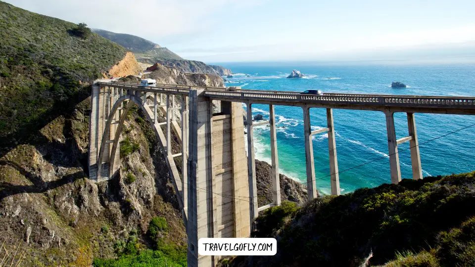 1. Marvel at Bixby Creek Bridge
This graceful concrete arch bridge is perhaps Big Sur most photographed landmark, featured in countless car commercials and social media posts.
Actionable Tip: For the classic shot, use the Castle Rock Viewpoint on the east side of Highway 1 just north of the bridge. Visit in the morning for the best light and fewer crowds. Be extremely careful with traffic when pulling over.
Location: Mile Marker 59.9 on Highway 1, approximately 13 miles south of Carmel
2. Explore Point Sur State Historic Park & Lighthouse
Perched atop a volcanic rock, this 1889 lighthouse stands as a sentinel over one of the most dangerous stretches of California coast, with fascinating history and spectacular views.
Actionable Tip: Tours are only available on specific days (typically Wednesday, Saturday and Sunday) and often sell out. Check the official website for current schedules and book in advance. Wear sturdy shoes and bring a windbreaker regardless of the season.
Location: Mile Marker 54.1 on Highway 1
3. Hike in Andrew Molera State Park
One of Big Sur’s largest state parks offers diverse trails through meadows, beaches and bluffs with relatively fewer crowds than other parks.
Actionable Tip: The Beach Trail (easy/moderate, 2 miles round trip) provides access to a beautiful, driftwood-strewn beach. Note that the seasonal footbridge over the Big Sur River is only installed during summer months; be prepared for a wet crossing or water shoes during other seasons.
Location: Mile Marker 51.2 on Highway 1, $10 day-use parking fee
4. Dine with a View at Nepenthe / Phoenix Shop
Perched 800 feet above the Pacific, this iconic restaurant has been serving travelers since 1949, featuring the famous Ambrosia Burger and unmatched coastal views.
Actionable Tip: Arrive for late lunch (2-4pm) to avoid the worst crowds. If there’s still a wait, browse the excellent Phoenix Shop below for unique gifts and books about the region. Vegetarians should try the delicious stuffed eggplant.
Location: Mile Marker 43.9 on Highway 1
5. Discover Pfeiffer Big Sur State Park (Redwoods & Trails)
The “mini Yosemite” of the coast offers accessible redwood groves, river access, and varied hiking options.
Actionable Tip: The Buzzard’s Roost Trail (3 miles round trip, moderate) offers tremendous valley views, while the Valley View Trail (1.5 miles round trip, easy) provides a more accessible sample of the park’s beauty. Check at the entrance for any trail closures due to fallen trees or erosion.
Location: Mile Marker 47.2 on Highway 1, $10 day-use parking fee
6. Find the Purple Sand at Pfeiffer Beach
Famous for its unique purple-hued sand and dramatic rock formations including the photogenic Keyhole Arch that perfectly frames the sunset during winter months.
Actionable Tip: The narrow, unmarked access road (Sycamore Canyon Road) is easy to miss. The purple sand is most vibrant after rainfall and is concentrated in patches near the northern end of the beach. Arrive early as the small parking lot fills by mid-morning on weekends and holidays.
Location: Mile Marker 45.7, then turn west on Sycamore Canyon Road. $12 day-use fee (cash only)
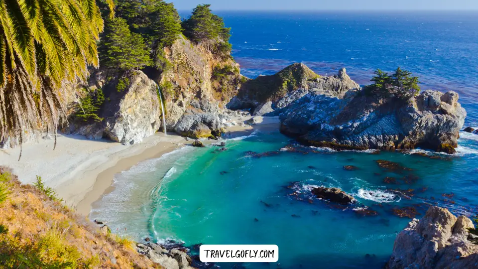
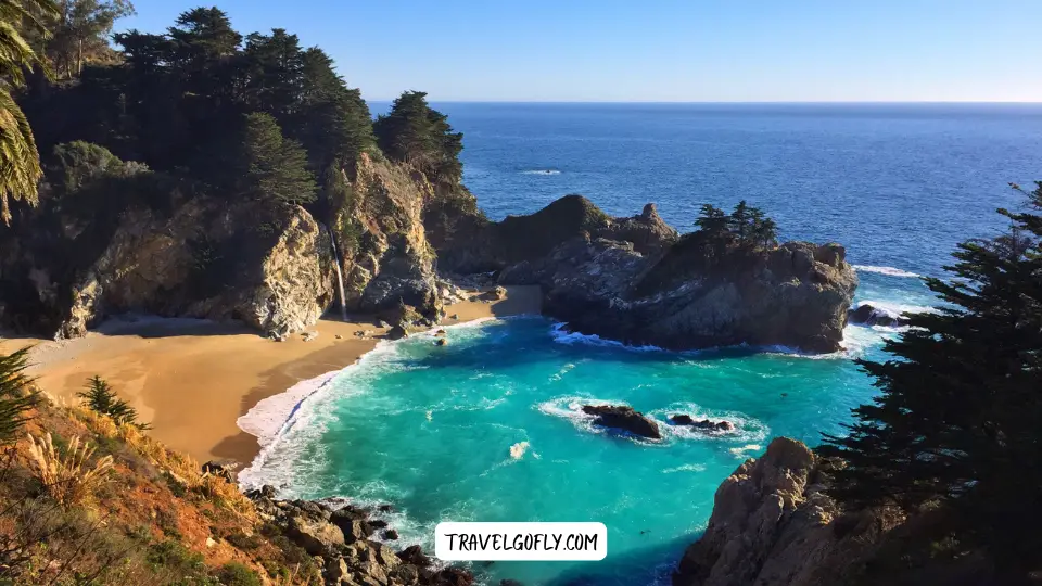
7. Gaze Upon McWay Falls (Julia Pfeiffer Burns State Park)
This iconic 80-foot waterfall cascades directly onto the beach (one of only two “tidefalls” in California) creating one of Big Sur’s most photographed scenes.
Actionable Tip: The Overlook Trail is short (0.5 miles round trip) and easy, but parking can be challenging. If the small lot is full, park legally along Highway 1 and pay the fee using the self-pay envelopes. Note that there is no beach access the cove is protected and off-limits to visitors.
Location: Mile Marker 35.8 on Highway 1, $10 day-use parking fee
8. Hike Partington Cove Trail
This hidden gem features a short but steep trail leading to a historic tunnel and secluded cove with beautiful turquoise waters and interesting tidal pools.
Actionable Tip: The descent is steep and can be slippery when wet. The trail splits after the tunnel—right goes to the rocky cove, left to a small wooden bridge with forest views. Always check trail status before visiting as it occasionally closes due to landslides.
Location: Mile Marker 37.2, look for small pullout on the east side of Highway 1
9. Experience Limekiln State Park’s Triple Attractions
This compact park offers three main attractions: a beach, historic lime kilns, and beautiful waterfalls accessible via short trails.
Actionable Tip: The Falls Trail (0.8 miles round trip, easy) leads to a 100-foot cascading waterfall, while the Kilns Trail (0.5 miles round trip, easy) showcases four massive iron and stone lime kilns from the 1880s.
Location: Mile Marker 21.2 on Highway 1, $10 day-use parking fee
10. Visit Sand Dollar Beach
The largest accessible beach in Big Sur offers a wide crescent of sand perfect for beachcombing, tide pooling, and even surfing when conditions are right.
Actionable Tip: The steep staircase leading down to the beach can be challenging for those with mobility issues. Low tide reveals extensive tide pools at the north end of the beach. Despite the name, sand dollars are rarely found here.
Location: Mile Marker 13.7 on Highway 1, $10 day-use parking fee (America the Beautiful passes accepted)
Dig Deeper: Unique Activities & Hidden Gems
 Find a Secluded Beach
While Pfeiffer Beach gets most of the attention, Garrapata State Park beaches to the north offer similar beauty with far fewer crowds. Check conditions for access to the trails leading to these hidden coves.
Go Whale Watching (Seasonal)
The Big Sur coastline offers excellent whale watching opportunities without a boat. Gray whales migrate December through April, while humpbacks are often spotted from June through September. The pullouts near Hurricane Point and the Bixby Bridge area offer excellent vantage points.
Browse Art Galleries
Big Sur’s dramatic landscape has long attracted artists. Visit the Coast Gallery and Sculpture Garden (housed in a historic redwood water tower) or Hawthorne Gallery to see works inspired by this magical region.
Indulge at the Big Sur Bakery
Hidden behind a gas station is one of the coast culinary treasures. Their wood-fired pastries and breads make for a perfect breakfast or afternoon treat in a charming garden setting.
Stargazing
With minimal light pollution, Big Sur offers spectacular night skies. Pfeiffer Beach and Sand Dollar Beach parking areas (before closure) provide good viewing locations, as do many of the higher elevation pullouts along Highway 1.
Big Sur Food Guide: From Casual Bites to Fine Dining
 Best Restaurants with Jaw-Dropping Views
- Nepenthe: Mid-range pricing with panoramic ocean views from almost every table
- Sierra Mar at Post Ranch Inn: Luxury dining with glass-walled views and an award-winning wine cellar
- The Sur House at Ventana: Elegant dining featuring ingredients from their organic garden
Casual & Delicious Stops
- Big Sur Bakery: Artisanal breads, pastries, and wood-fired pizzas in a rustic setting
- Big Sur River Inn: Enjoy burgers and sandwiches while sitting in chairs in the actual river
- Fernwood Resort Tavern: Local hangout with good pub food and occasional live music
- Big Sur Taphouse: Craft beers and simple but delicious food in a relaxed atmosphere
Picnic Supplies & Groceries
- Big Sur Deli & General Store: Basic groceries and made-to-order sandwiches
- Big Sur Roadhouse Market: Limited but high-quality provisions
- Ripplewood Resort Store: Small but useful selection of essentials
Putting It All Together: Sample Big Sur Itineraries
The Perfect Big Sur Day Trip (From North)
- Morning: Bixby Bridge photos, brief hike at Garrapata State Park
- Lunch: Nepenthe for the classic Big Sur dining experience
- Afternoon: McWay Falls at Julia Pfeiffer Burns State Park
- Sunset: Pfeiffer Beach (time permitting)
A Relaxing Big Sur Weekend (3 Days / 2 Nights)
Day 1:
- Drive in, stopping at Bixby Bridge and Point Sur Lighthouse
- Check into accommodation
- Sunset at Pfeiffer Beach
Day 2:
- Morning hike in Pfeiffer Big Sur State Park
- Lunch at Big Sur Bakery
- Afternoon visit to McWay Falls
- Dinner at your lodging or nearby restaurant
Day 3:
- Morning beach walk at Andrew Molera State Park
- Browse art galleries and shops
- Late lunch at Nepenthe before departing
The Adventurer Big Sur Itinerary
Focus on these hikes for those seeking more active experiences:
- Andrew Molera Loop Trail (8.8 miles) for beach and bluff views
- Ewoldsen Trail in Julia Pfeiffer Burns State Park (4.5 miles) for redwoods and ocean vistas
- Tan Bark Trail (6.5 miles) for a challenging ascent with big rewards
- Mount Manuel Trail (8 miles) for serious hikers seeking panoramic perspectives
Travel Responsibly in Big Sur
This fragile ecosystem depends on visitors respecting its natural boundaries:
- Pack out everything you bring in, including food scraps
- Stay on designated trails and respect all closure signs
- Never remove natural items (rocks, plants, sand) as souvenirs
- Use turnouts when stopping for photos or to let faster traffic pass
- Support local businesses rather than large chains
- Never trespass on private property, which comprises much of Big Sur
- Be fire aware follow all fire restrictions and properly extinguish cigarettes
Final Thoughts on Big Sur
Big Sur isn’t just a destination it’s an experience that stays with you long after you’ve left its winding roads behind. The unique combination of mountains plunging into sea creates not just spectacular views but a feeling of standing at the edge of the world that is increasingly rare in our developed world.
While the attractions and restaurants may evolve, the timeless magic of Big Sur remains constant. By planning carefully, driving mindfully, and approaching this special place with respect, you’ll discover why generations of artists, writers and travelers have found inspiration along this remarkable coastline.
What are your favorite things to do in Big Sur? Share your tips or questions in the comments below!